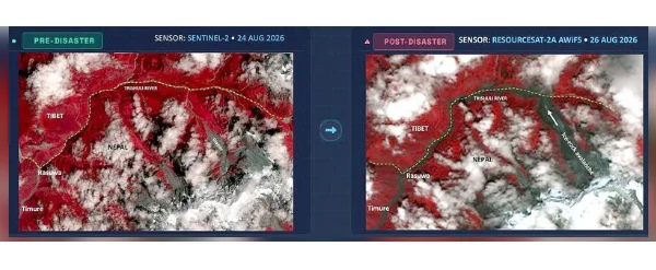
New Delhi, Aug 27: Satellite images released by the Indian Space Research Organisation (ISRO) have revealed significant surface changes in a glacier near the Trishuli River, close to the Nepal-Tibet border, following the devastating floods that struck Nepal on August 25.
A preliminary analysis by ISRO's National Remote Sensing Centre (NRSC) has mapped extensive changes in the high-altitude glacier region, with the findings pointing to an ice-rock avalanche or landslide that may have temporarily blocked a river before a sudden release of water and debris triggered flash floods.
The analysis was carried out using satellite data from Resourcesat-2A, an Earth observation and remote-sensing satellite.
The satellite images show a wide zone of disturbance around the glacier near the Trishuli River, along with a swollen Bhote Koshi river and extensive flooding downstream.
According to the preliminary assessment, the sequence began with an ice-rock avalanche or landslide that caused temporary impoundment of river water. The subsequent release of the trapped water and debris led to a powerful surge along the Trishuli river system.
The Trishuli, which originates in Tibet, is a major tributary of Nepal's Narayani river system and flows through central Nepal before eventually joining rivers that drain into the Indo-Gangetic plains.
Nepal witnessed severe flooding on August 25, causing widespread destruction, deaths and disappearances, particularly in northern areas. Rasuwa district near the China-Nepal border was among the worst affected.
Although the initial flood surge has subsided, authorities remain alert to the possibility of secondary flooding. Experts have warned that debris and ice avalanches can create temporary natural dams, which may later collapse and cause sudden additional surges.
The NRSC is responsible for acquiring and processing remote-sensing satellite data and supporting disaster management through satellite-based information and analysis.