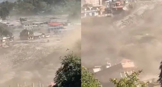
GYIRONG (Tibet-Nepal border), Sept 6: Dramatic images emerging from the Tibet-Nepal border have revealed the devastating impact of the August 26 flash floods, including footage showing a massive wall of mud, rocks and debris engulfing a border immigration post within seconds.
The video, which went viral globally, captured the sheer force of the disaster and the destruction caused to infrastructure and human lives.
The extent of the devastation had so far been largely documented from the Nepalese side, where the death toll has crossed 1,300 and around 5,000 people remain missing.
The disaster was triggered by an ice-rock avalanche near the Nepal-Tibet border on August 26, sending a huge surge of water and debris downstream through the Bhotekoshi River and devastating settlements across northern and central Nepal.
China on Sunday, for the first time, allowed PTI and select foreign media access to Gyirong County in Tibet, where the border immigration post was destroyed, to witness the devastation and ongoing relief and reconstruction efforts.
Chinese authorities are rebuilding roads to restore access to the affected border crossing and have also sent relief supplies to Nepal.
According to official figures from the Chinese side, 31 people were killed and 531 remain missing in Tibet. The missing include 261 foreigners, among them 49 Indians and 22 nationals from other countries.
Many of the foreign nationals were believed to have been on either side of the ill-fated immigration facility when it was swept away by the floods.
China said a preliminary assessment jointly conducted by Chinese and Nepalese authorities concluded that the disaster was caused by the collapse of a high-altitude glacier in Nepal.
Chinese Foreign Ministry spokesperson Lin Jian said on August 28 that experts and official institutions from both countries had made a preliminary assessment pointing to the collapse of a high-altitude glacier as the trigger.
The sudden glacier collapse has raised concerns among scientists over the possibility of similar disasters in the future.
Gao Rong, deputy director of China's National Climate Centre, warned that glaciers across the Tibetan Plateau could become increasingly unstable, potentially triggering more collapses and cascading disasters.
Over the past six decades, the glacier-covered area on the Tibetan Plateau has shrunk by about 24 per cent, with around 7,000 small glaciers disappearing completely, Gao said.
He warned that the structural stability of glaciers is expected to decline further, increasing the likelihood of glacial disasters and their potentially wider impact through cascading effects.
The Institute of Tibetan Plateau Research under the Chinese Academy of Sciences said its analysis showed that the mudslide generated by the glacier collapse travelled about 22 km through the valley and reached Gyirong Port in just seven minutes.
Researchers said disaster assessments should no longer focus solely on the initial collapse, but also consider the chain of hazards that can follow.
Analysis of satellite and field data showed that collapsing ice and rocks swept through the valley, scoured the riverbed, carried debris from the banks and mixed with water, transforming the high-altitude collapse into a powerful mudslide.
Chinese researchers have called for disaster-risk assessments to incorporate such cascading hazards linked to the high-mountain cryosphere.
The disaster has also renewed concerns among countries downstream of the Tibetan Plateau, particularly as China continues to develop large-scale hydropower projects in the region, where any major natural disaster could potentially have far-reaching consequences.